


 Media Coverage
 Press Release
Revolutionizing Infrastructure Reporting with Automation
A Geospatial Analytics Transformation Story
Enabling Efficiency Through BI Modernization
Streamlining Infrastructure Oversight
Infrastructure Reporting Challenges
Implementing Automation with Modern BI
Tools and Technologies Deployed
Operational Impact and Measurable Outcomes
Enhancing Accuracy with Real-Time Dashboards
Integrating Geospatial Data into BI Workflows
Scalability and Future Readiness
Business Impact and Client Feedback
In Brief
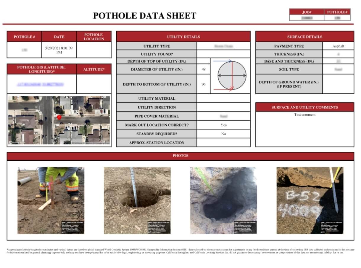
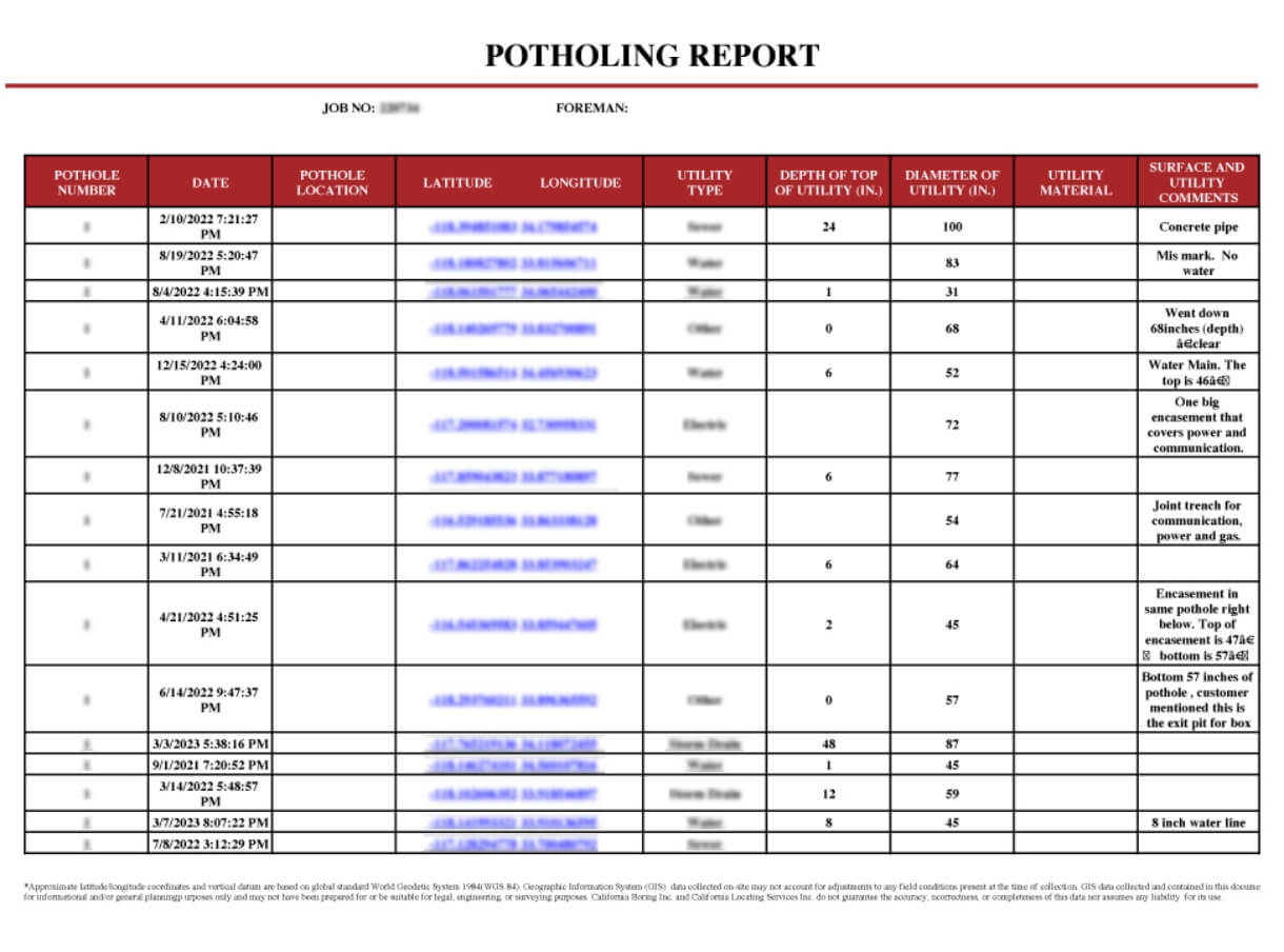
A US-based geospatial services firm catering to urban utilities and public works departments was unable to automate reports on newly identified potholes, leading to delays in addressing safety concerns for drivers and pedestrians. To help the customer overcome this challenge Pixel Perfect for Tableau provided multi-report exporting with custom branding & styles, dynamic numbering logic for potholes, customized data representation and dynamic image export. Automated Calboring Potholing Report was distributed with pothole summary grouped by job ID, pothole location map and details of potholes images in a well-formatted, customized pdf. As a result, the firm was able to automate reporting, improve communication, and address potholes within set Service Level Agreement (SLA) of 24 to 48 hours.
Customer
The customer is an industry leader in geospatial services and cloud spatial solutions. It has been servicing local, county and state government agencies for over 30 years. The company’s flagship applications are designed for local government and private organizations. They provide real-time operations management, BI & GIS based reporting, streamlined work management, powerful analysis tools, and connected device monitoring. The customer has successfully enabled more than 100 organizations with smarter technology that delivers optimal efficiency, effectiveness, and ROI.
Business Challenges
Due to lack of wholistic BI Reporting, the customer was unable to address concerns on newly identified potholes, leading to delays in addressing safety concerns for drivers and pedestrians.
USEReady Solution
To address this issue, USEReady deployed Pixel Perfect for Tableau. The Tableau extension provided the customer multi-report exporting feature with custom branding & styles, dynamic numbering logic for pothole, customized data representation and dynamic image export. Automated Calboring Potholing Report was distributed with pothole summary grouped by job ID, pothole location map and details of potholes images in a well-formatted, paginated customized pdf report.
Key Outcomes
Implementing STORM led to multiple advantages including

Automated reporting for 150+ operations managers, line managers, job owners and foremen

Accelerated identification and resolution of pothole issues

Improved public safety around pothole hazards

Increased operations efficiency with faster, error-free reporting leading to 95% SLA compliance
Lessons Learnt
The case study offers ample illustration of Pixel Perfect’s versatility in addressing a wide variety of reporting challenges. Its multi-report exporting feature with custom branding & styles, dynamic numbering logic for pothole and customized data representation and dynamic image export capabilities addressed challenges for an extremely niche use case. The solution is scalable and can be used to generate fully formatted and print-ready forms, at scale – as and when required, at the click of a button from the Tableau dashboard.
Conclusion
This case study shows that infrastructure management companies facing operational reporting challenges can maintain both efficiency and public safety when upgrading their data systems. By combining automated reporting with geospatial visualization, the firm transformed manual pothole documentation into a streamlined process that consistently meets critical response times. As utilities and public works departments deal with growing infrastructure demands and tight budgets, this implementation offers a practical blueprint for specialized reporting tools that enhance visualization platforms to meet industry needs, ultimately improving both public safety and operational performance through more efficient reporting.

Download your Case Study
1407 Broadway, Suite 721
New York, NY 10018
+1 (212) 370-0000